
 Distance
 Elevation
 Observed Wildlife
to
Two nights of camping at the base of Mount Carrigain brought me to remote woods, alpine lakes, gorgeous cascades, and a monumental view.
Day 1 - 6.4 miles - 3 hours, 54 minutes


I was so excited to embark upon this solo hike and I was not disappointed. Like a kid on Christmas morning, I got up at 5AM in order to get on the trail by 8. I started at the Signal Ridge Trailhead. The trail began on a very easy grade interspersed with some puncheons (pictured above on the left), I do love me a good set of puncheon. The trail followed Whiteface and the Carrigain Brooke. I was able to make quick work of the first three plus miles. Amid this, I turned right onto Carrigain Notch Trail.
I took my first break after the trail met with Carrigain Brook and I caught a peek of Mt Simon. I creatively made my way through some brush to a fallen tree above the quiet stream, and enjoyed my snack. In retrospect I would have enjoyed a better break right before Carrigain Notch in an open are with a partial view of Mount Simon. I was surprised at how quickly I made it to the highest point of the day’s hike.


The next portion of my hike was by far the buggiest of the entire three days, but was occompanied by a very wild feel through some wetlands. The trail itself was fairly dry as not much rain preceded my hike. At one point I was lucky to catch a glimpse of, what I believe was, a gray fox. It must have seen me before I saw it, so I only watched the back of it pounce through the undergrowth, away from me. Whatever I saw, I loved the remoteness the trail offered.


When I reached the intersection with Nancy Pond Trail I took a very quick detour to enjoy the serenity of Notch Brook. Check out the video, below, and this photosphere to get your own sense of it. In addition to its beauty, the moving water (and my freshly applied bug spray) kept the bugs away and I relaxed on a rock in the middle of the brook. Although I didn’t want to leave, I took solace in the fact that I would be crossing this stream twice more on the following day.
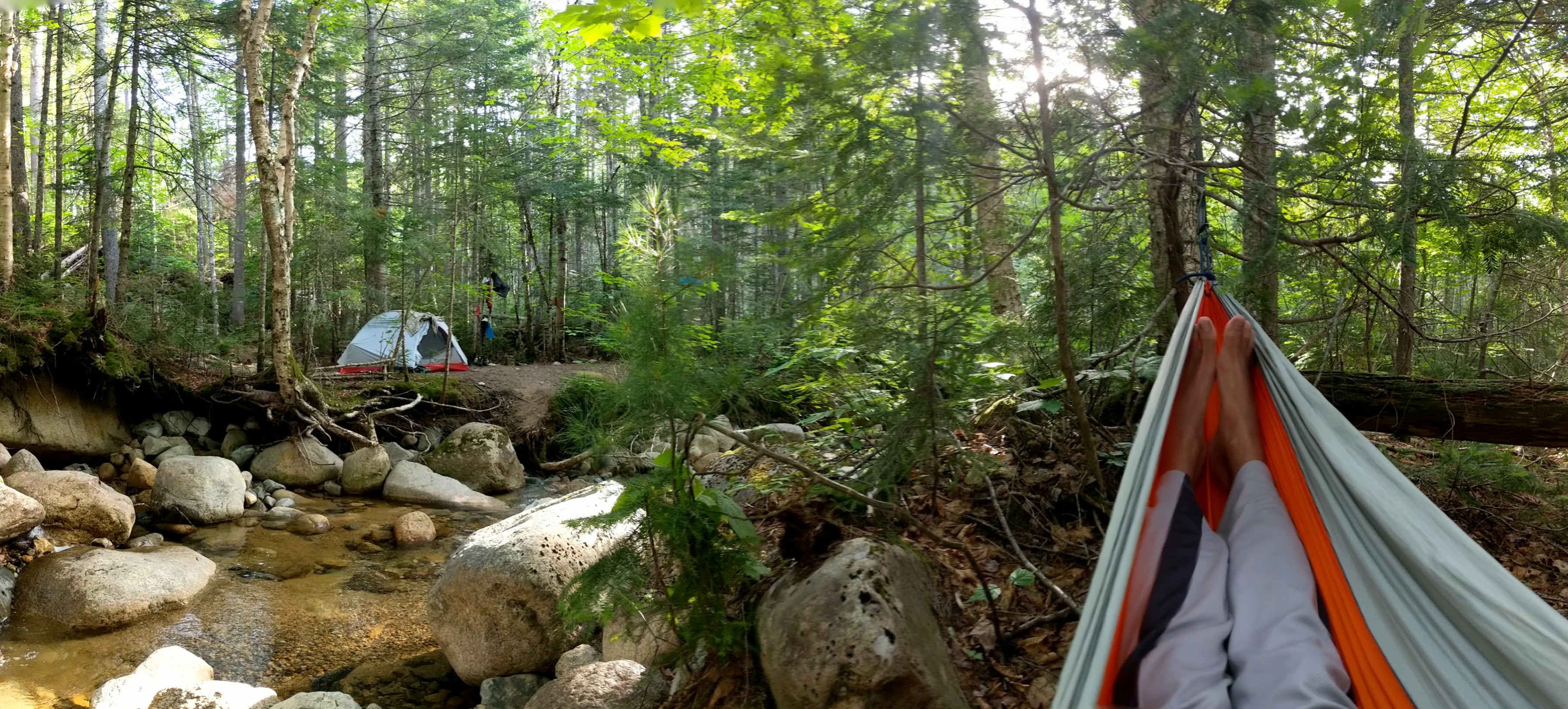
The rest of the day’s hike was through a virtually straight and flat section of Carrigain Notch Trail. I reached the location of my campsite, the intersection with Desolation Trail, before noon. There was a big site immediately at the intersection, but many more preferred sites offered more privacy and proximity to Carrigain Branch. I took a spacious site right before another brook flows into Carrigain Branch. I crossed the brook to reach it.


While I was still warm from my hike, I wanted to take a dip in the cool mountain water. Before setting up my site I left my pack and walked down the brook to find a place to rinse off. As I walked downstream, the scenery improved with every step. The rocks turned into big granite slabs for the water to run over. It also offered a couple views of Mount Carrigain looming over me. I was able to submerge in a few deeper pools, and I felt so refreshed. Then I returned to my site and set up my tent and hammock on opposite sides of the brook and spent the rest of the day hanging out in my hammock and listening to the running water. It was a beautiful place to spend two nights.
Day 2 - 10.0 miles - 8 hours, 19 minutes


I woke up on Saturday excited to explore without my big pack, I equipped myself with my lightweight barefoot running shoes and a tiny Camelback. I was on the trail by 8AM and heading back the way I came on Carrigain Notch Trail. I quickly covered the three quarters of a mile to Nancy Pond Trail. That was followed by a flat stretch through four easy water crossings intersperced with a jaunt through some short hemlocks, which felt like nature’s tunnel. After the last crossing, I started to gain elevation, but at a steady rate in which I was able to make quick progress.


I cotninued to feel like I had the woods to myself. It was obvious I was the first to make my way through the trail by the dozens upon dozens of spider webs I took down. This uphill section was uneventful except for a variety of mushrooms and a few toads hopping their way across the trail. I had covered 3.4 miles and gained 800 feet of elevation in about 75 minutes to reached the amazing alpine Norcross Pond.
This was a spectacular place to take a rest. The pond was on one side and a gorgeous view of the Bonds lied on the other. When I resumed, I took a more leisurely pace through the continuous beautiful scenery. Initially, I tried following the advice of the AMC White Mountain Guide by following a trail on the right side of the pond along the shore. I must have made a mistake because there were many rocks directly on the shore that I thought was the path. I hopped from rock to rock until I realized that this was merely the shore and no real path or dry land existed. I took great care to step only on rocks and dead wood in order to preserve the alpine vegetation and the dryness of my feet. At this early hour, the remote pond was all mine. The lily pads, dragonflies, frogs and Mount Nancy were great company. I spotted what I thought to be moose tracks and saw two beaver dens, but was not graced by any large mammal sightings. This vr picture gives a sense of how great a place this pond really was.

After almost an hour, I made it to the other side of the pond and passed Upper Norcross Pond, which I could only enjoy from a safe distance as no solid footing exists along the shore. I crossed the boundary from the Pemigewasset Wilderness into the The Nancy Brook Research Natural Area which my AMC guide describes as, the almost imperceptible height of land.
Much of the trail is made of puncheon and it didn’t take long to arrive at Nancy Pond. I was still on high alert in hopes of seeing a beaver or moose. I watched some ducks swim across the pond, but still no mammals.


The trail got quite steep as I descended through the rooty trail in old growth forest as I approached upper Nancy Falls. I veered off trail to a spot between two small sections of the falls to take in a lovely east facing vista. As I descended, there were a few more opportunities to view sections of the falls, but by far the best was at the lower falls. I was joined by many other hikers who rested in a large clearing at the foot of the falls right in front of a small pool. It was just after 1PM, 5 hours into my hike.


I had reached the terminus of my hike and made my way back up the steep trail parallel to the falls. I took another short rest at a peaceful opening on Nancy Brook just above the upper falls. I returned past Nancy Pond and the multiple campsites near its shores. There were also a few sites at the far end of Norcross Pond. I stopped one more time at the end of Norcross Pond to take in my last open vista of the day.

I made quick work of the descent due to my light pack, running shoes, and the forgiving grade. I returned to my site, took a quick dip, and then nestled into my hammock. I fell in love with my sight during these two nights and wish to return to the brook some day (a vr photo to give you a sense). For anyone planning on camping in the area, there is another great, much bigger, site further down the trail (probably about ¼ or ⅓ of a mile from the intersection) above big granite slabs and a swimming hole.
Day 3 - 6.4 miles - 5 hours, 6 minutes
On Sunday morning I woke up, packed up my site, and grew anxious about carrying my backpack up twenty-five hundred feet to the peak of Mount Carrigain. This elevation was covered in less than two miles so I took a decidedly measured pace up the mountain. About halfway up, I started to catch glimpses of the basin from which I came. The trail was consistently very steep yet manageable and did not require any scrambling. Don’t get me wrong, the trail is intimidating in its steepness at times, but at the right pace, I completed it without too much trouble.


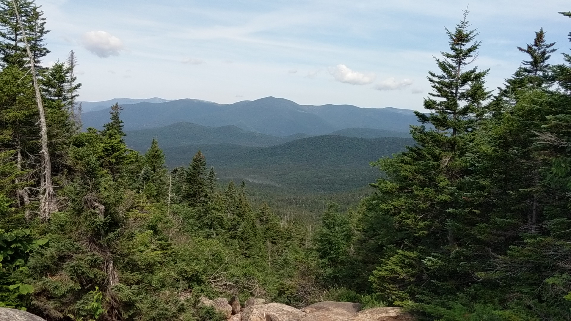
I adopting the mindset that the climb would take the better part of the morning and was surprised when I reached the summit with virtually no warning. The wind was immediately apparent and I put on every layer I packed before climbing up the fire tower. Once atop, the view was absolutely stunning. Mount Carrigain is much higher than its immediate neighbors, and I saw so many peaks throughout the White Mountains. Unfortunately, the presidentials were hidden behind the clouds, but I was able to trace the many peaks that make up the Pemi Loop as well as all the peaks of the Sandwich Range. The most beautiful direction was looking down at and beyond Signal Ridge. This poor attempt at a vr panorama and this video only give a small sense of the beauty that awaits you atop this mountain.

After about a half hour resting, snacking, and absorbing the view, I climbed down the tower and started the lengthy descent to my car. I passed a designated campsite at the summit and passed many hikers on their way up. Signal Ridge continued to offer many views of Mount Carriganin and its surroundings. When I reached the last viewpoint, it was hard to leave it all behind and descend back into the woods.


The next hour and a half required a slower pace down steeper terrain. The evergreen forest gave way to lowland hardwoods as the descent became more forgiving. As this transitioning occured, I crossed a tiny stream over a short bridge and took a seat for my last break and snack. Shortly after, I reached the intersection with Carrigain Notch Trail and powered through the last two miles. I reached my car at 1:15, and concluded another amazing wilderness experience.


